Oxford University Expedition 2008: An orchid inventory along the transects II and IV of the InterOceanic Highway.

Location of the Interoceanic Highway in Latin America
The Interoceanic Highway is a multi-country, multi-region, $1.3-billion project to create a paved highway that links the Peruvian coast with the lowland Amazon Jungle and ultimately the Atlantic ports of Brazil. Peru is counting on the road as a means of opening up its long-neglected interior for development. Brazil is looking for access to Pacific ports. The finished route, planned for 2009, will create the first paved roadway connecting the Atlantic and Pacific oceans on the South American Continent.
A traveller through Southern Peru can wake up in the harsh chill of the high Andes in the early morning and spend the evening sweating it out in the jungle. From an engineering point of view the IOH poses a legion of difficulties including extreme elevations, incessant downpours and dramatic geography. “It is an incredibly complex project”, says Peru’s Minister of Transportation and Communications, Veronica Zavala. From a social point of view the highway links a variety of interests and development hopes that are not always lined with environmental governance initiatives.

Among the major goals of our expedition was the development of a comprehensive inventory of as many orchid species as we could identify (e.g. we found 103 species of orchids in flower, 1 of them has already been confirmed as new to science (Telipogon manucensis), and 3 others are pending examination. Orchids are an excellent ‘indicator species’ in ecology, and their delicate, often soil-less existence usually renders them the most sensitive residents of a changing environment. We now possess a snapshot of the ecosystem from July 2008, ready to be compared to a later snapshot to evaluate how seriously industrial road-building, climate, and social pressures can affect biodiversity.
-
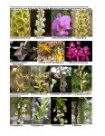
- Peruvian Orchid Inventory 1 of 8
-
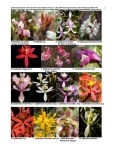
- Peruvian Orchid Inventory 2 of 8
-
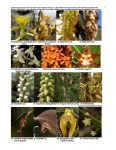
- Peruvian Orchid Inventory 3 of 8
-

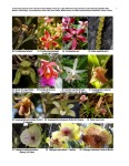
- Peruvian Orchid Inventory 4 of 8
-

- Peruvian Orchid Inventory 5 of 8
-

- Peruvian Orchid Inventory 6 of 8
-
- Peruvian Orchid Inventory 7 of 8
-

- Peruvian Orchid Inventory 8 of 8
-

- Location of the Interoceanic Highway in Latin America
In order to share our data with the scientific botanical community, our records will be entered at Oxford’s Virtual Field Herbarium, and also transformed into Rapid Color Guides at the Chicago Field Museum’s website. Our inventory is also being used as part of an ecotouristic initiative to promote green tourism along the Interoceanic Highway.
Expedition members: Rosa María Román-Cuesta (Expedition Leader), Norma Salinas Revilla (Leading Botanist, Oriel College), David Rueger (Financial Officer, St Hugh’s College), Theresa Meacham (Pembroke College), William Nauray (Botanist), Quintin Lake (Medical Officer and Photographer).
Our utmost gratitude to our sponsors: The Stanley Smith (UK) Horticultural Trust; The AA Paton Fund; The Oxford University Expedition’s Council; The Mike Soper Fund; The Oxford Society; Pembroke College JCR,, Oxford; St. Hugh’s College Travelling Funds, Oxford; The Anglo-Peruvian Society; The Tambopata Reserve Society (TReeS)


Download the PDF photo summary of the orchids here
VIEW MORE IMAGES of the Orchids here
VIEW MORE IMAGES of the Expedition here
VIEW MORE IMAGES of the Interoceanic Highway here
Text © 2008 Rosa Maria Roman Cuesta
Maps & Photography © 2008 Quintin Lake


